‘Alarming precedent’ – Liesbeek River under siege again


Little has been learnt from the long history of development along the Liesbeek River, said UCT’s Dr Kevin Winter. The river is under siege again by development along its banks.
The Liesbeek River is living symbol of a South Africa characterised by land dispossession, heritage loss, irreparable damage to ecosystems, accompanied by significant social and political conflict, and risk to water security and climate change. But the river is under siege again by development along its banks, writes Dr Kevin Winter of the University of Cape Town’s (UCT) Future Water Institute.
The Liesbeek River flows through some of the oldest suburbs of Cape Town. Only a few sections of the river channel would be recognisable to the Khoi and San people who lived in the valley in precolonial times. The same could be said of many urban landscapes, but in the case of the Liesbeek, the significance is not only about what has changed, but how it has changed.
About 70% of the river is modified by canalisation, which has altered its physical form and shape. But the physical appearance today hides a history of change and regret.
Record of a bygone era
Until the late 19th century, the Liesbeek provided a reliable, high-quality water supply to the Khoi and San peoples and early colonialists. Accounts found in Jan van Riebeeck’s diary describes the condition of the Liesbeek valley and the commercial potential of the natural environment.
Extensive hardwood forests surrounded water courses along the eastern slopes of Table Mountain and aligned the Liesbeek River. Van Riebeeck claimed that he saw “the finest and richest arable and pastureland in the world”, and that the valley was “wide and level” with “countless fresh rivulets”.
In 1654 a visitor to the Cape described the Liesbeek as a deep river that was navigable by boat from the fort at Cape Town to present day Bishopscourt. Wildlife was plentiful with herds of antelope, hippopotami, lions, leopards and hyenas. A variety of water birds were found in wetlands of the lower Liesbeek River that flowed directly into Table Bay.
By 1657 Dutch farmers, called Free Burghers, transformed the natural vegetation on the western side of the river and forcefully dispossessed indigenous peoples from the most arable and valuable land alongside the Liesbeek. In 1659 the Khoi made the first attempt to resist the European invasion of their lands but could not match the Dutch firepower. Subsequently, a hapless peace agreement was reached in 1660 that gave the Dutch sovereignty over the Liesbeek valley.
The settlers continued to transform the natural landscape by expanding their agricultural activities and by introducing milling and brewing industries along the riverbanks. Gradually the role of the Dutch East India Company declined with the arrival of British settlers in 1795. The Cape colony was eventually ceded to the British crown in 1814.

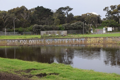
Silent protest along the lower Liesbeek River canal.
The British rapidly transformed the Liesbeek valley into residential suburbs, which resulted in significant changes in the natural drainage of the river and its channel. Properties encroached on the riverbanks often had boundaries that extended into the river and gave property owners riparian rights to the water. Unintended consequences followed. Between 1930 and 1960 various stretches of the river were canalised to control flooding and to prevent ponding and a breeding ground for mosquitoes.
Growing awareness of the value of urban rivers
Two complementary shifts in thinking were partially responsible for improving the outlook and potential of the Liesbeek River. In the 1980s the western world became increasingly aware of the impact of development on the environment. This awareness was spurred on by the rise of environmentalism and use of environmental impact assessments (EIAs) as an instrument to inform development decisions and their impact on the environment.
There is some evidence of this influence, for example, when the Cape Town City Council adopted the Greening the City report (1982), which proclaimed that the city’s rivers should be regarded as vital recreational and aesthetic amenities and conservation corridors of urban environment.
The implementation was short-lived or limited at best. A second, and arguably more significant trend, was associated with the preparation and aftermath of the Earth Summit in 1992 that carried the slogan “Think global, act local”. In 1991, in anticipation, a small group of concerned citizens formed the Friends of the Liesbeek with the intention of generating public awareness and community involvement in the Liesbeek River.
In its mission statement, the Friends hoped that the public would “regain the freedom of the river”, for present and future generations. That aspiration has continued ever since, making it one of the strongest and most respected environmental community-based organisations, which has won several awards for its voluntary work.
A river under siege
The struggle continues.
“The developers and consultants argue that the site is degraded, but the present state is only the result of neglect and mismanagement.”
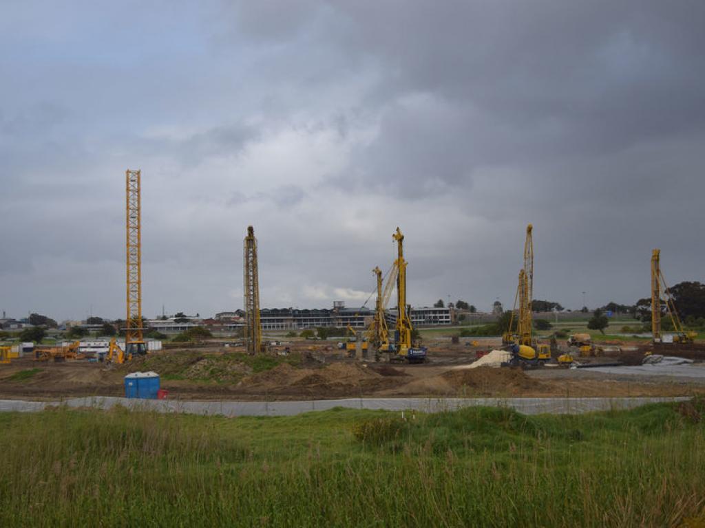
The current development at the River Club on floodplains of the lower Liesbeek suggests that very little has been learnt from a history of abuse of the river. The development is set to alter a conservation-worthy corridor and infill one of last remaining sections of the Liesbeek River. The developers and consultants argue that the site is degraded, but the present state is only the result of neglect and mismanagement.
Despite the degraded condition of the floodplain, nature bounces back. When the driving range and golf course at the River Club were inoperable because of COVID-19 lockdowns, various species returned to a safe habitat on the site. Threatened western leopard toads and Cape dwarf chameleons that are rarely seen in urban areas along the river, among other species, were found during the search and rescue operation prior to commencement of the development.
This shouldn’t come as a surprise since the site is a precinct of the Two Rivers Urban Park comprising “sensitive ecological systems and habitats” (City of Cape Town [2003] Two Rivers Urban Park contextual framework and Phase 1 Environmental Management Plan (Final Report), Environmental management Branch, City of Cape Town).
The City’s own Spatial Planning and Environmental Management Department professionals appealed the decision for the development to go ahead and cited several reasons including:
- insufficient mitigation of stormwater impacts, including flooding
- that due consideration was not given to climate change impacts and resilience
- that the decision does not appropriately describe, or mitigate, the loss of open space on site
- and that the decision does not appropriately describe or mitigate the high negative biodiversity impact or habitat loss of a high faunal sensitivity.
The appeal was rebuffed and dismissed. It sets an alarming precedent.
“It seems that not much has been learnt from 350 years of the development of the Liesbeek.”
Regrettably the current development has left many unanswered questions about the integrity of the EIA process and the extent to which social justice and environmental sustainability are considered in shaping the development of Cape Town.
A well-executed, credible EIA, especially in this case of a river catchment, considers the integration of site-specific and interconnecting social and biophysical factors, among others, that are informed by stakeholders, and specialist scientific and local knowledge.
The final decision has a hollow ring – a reminder about how excited Van Riebeeck must have been when he reported to his directors in the Dutch East India Company about the commercial benefits of the Liesbeek. History repeats itself: economics take precedence over the environment.
It seems that not much has been learnt from 350 years of the development of the Liesbeek. Future generations will regret that the authorities and private developers did not recognise the need to make room for the river, value the ecological services of a river that will mitigate climate change and secure water resources in the future.
Story: Kevin Winter
Photos: Kevin Winter
