New study on nitrogen pollution in False Bay


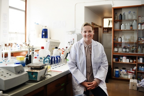
Dr Sarah Fawcett’s study will identify and monitor sources of nitrogen pollution in False Bay. Photo Robyn Walker.
The study aims to identify the sources of nitrogen pollution to the bay, evaluate how far offshore the pollution can persist and, through a dedicated monitoring programme, understand what happens to it once it enters the water. Fawcett hopes the study will support a long-term monitoring plan for the bay.
“Just understanding the chemistry of False Bay’s water and what affects it will provide a valuable baseline for oceanographers,” she says.
A chemical baseline will also help oceanographers understand the effects of poor water quality on small-scale fishers. Ultimately, she’d like to develop mechanisms to communicate predicted declines in water quality to this community.
Fawcett is one of five UCT researchers who recently received Claude Leon Merit Awards. These recognise meritorious scholarly work by early career academics in the natural sciences, medical sciences and engineering. Her accolades include a Mail & Guardian’s Top 200 Young South Africans of 2017 award and the South African Network for Coastal and Oceanic Research’s 2017 Young Researcher Award.
Dream funding
The Claude Leon award comes with “no strings attached” – possibly every researcher’s dream.
“It’s meant [for researchers] to do something that’s a little bit different, new and interesting,” she says.
Fawcett has a PhD from Princeton University in collaboration with the Bermuda Institute of Ocean Sciences. Her broad area of research encompasses understanding the complex relationships between oceanic biogeochemical fluxes, such as those of nitrogen and carbon, and the fertility of marine ecosystems, with implications for past and future climate.
As an open-ocean oceanographer, working on the coastal ocean presented a new challenge.
“False Bay offered some intriguing revelations,” she says. “The water quality in False Bay is better than you might expect, given the high population density along its shores. It’s thought that it is due to very rapid circulation, unlike many other bays where the water gets stuck in the bay and remains pretty stagnant.
“In False Bay when the southeaster is blowing, the opposite is true: water circulation is so fast that it’s flushing out the bay, diluting it with open-ocean water.”
But there are pockets in the bay that become stagnant, and periods when the southeaster isn’t blowing, affecting small-scale fishery. Frequently measuring the chemical make-up of the water will provide a high-resolution picture of water quality and how water circulation affects this balance.
“We want to use regular measurements of chemicals in the bay to understand and quantify the pollutant sources to the bay. So, how much pollutant is coming into the bay, where it is coming from and what’s happening to it, how much has been flushed out by ocean circulation, and how much has been ameliorated by the biological community that already lives there.”
Measuring nitrogen
Fawcett will begin by measuring False Bay’s nitrogen levels. (Nitrogen is a universally required nutrient in ecosystems that exists in many different forms and is relatively easy to measure.)
“The bay’s nitrogen comes from an array of sources: agricultural run-off (fertilisers are nitrogen-rich) and traffic pollution deposits on the sea surface. Then there’s the grey water from the Macassar Waste Water Treatment Works. There’s also the massive aquifer on the Muizenberg side, which contributes to groundwater seepage into the bay.
“Groundwater is one of the most notoriously difficult things to measure and to quantify how much is seeping into the bay. The groundwater also brings with it chemicals, both natural and human-derived, from whatever the catchment is for that aquifer.”
The brown water off Strandfontein, which occurs during large phytoplankton blooms, also holds some clues. This biological community that lives in the False Bay surf zone is thought to help keep the bay’s water quality healthy because it removes high levels of nutrients and prevents them from reaching the offshore ecosystem.
“But are these plankton growing because of an input of pollution or because of a strong input of nutrients from the open-ocean circulation? It’s important to get a benchmark so that we understand the feedbacks among the water circulation, the chemistry and the biology.”
Isotope trackers
Fawcett and her small team will measure the bay’s nutrient concentrations every two months over the next year. The isotope ratios of the chemicals will enable them to trace where the water comes from. This will provide a clearer picture of how much of the nutrient sources are true pollutants: how much comes from the aquifer or from the open ocean.
They will also use the isotope measurements to investigate how much of the contaminants the microbial community (such as plankton) process, which improves water quality in the bay.
“But we don’t know how important that role is. And if that were to change in the future – for example, if a particular species responded poorly to warming temperatures – that might have major implications. It’s way beyond the scope of the study, but if we don’t have a baseline, how do we even start thinking about change?”
Fawcett was first introduced to marine applications of isotope geochemistry while working on the Great Barrier Reef as an undergraduate. There she studied geochemical proxies for sea surface temperatures and El Niño, recorded in 10 000-year-old corals.
Most of the measurements can be done in the oceanography department, except the isotope measurements. Fawcett’s intermediate-term plan is to build capacity to do that at UCT. A new laboratory in construction will hopefully eventually enable them to make high-resolution, sensitive isotope measurements.
“As yet, there are no facilities in South Africa to make the type of measurements required for this work,” says Fawcett. “Such nitrogen isotope measurements can be applied to all sorts of things, questions of climate in the past, archaeology, biology, so you can use the methods for very many other things and open up a world of understanding.”
The laboratory will be the first of its kind in Africa and will support other work and analyses in the department, the university and the broader South African research community.
“In Oceanography, we’re starting to build a sea-ice programme (under the leadership of Associate Professor Marcello Vichi). My contribution will be to measure the various chemicals in the sea ice and their isotopes in order to improve our understanding of nutrient cycling within the ice. Currently we know very little about it.”
The laboratory should be completed by the end of the year.

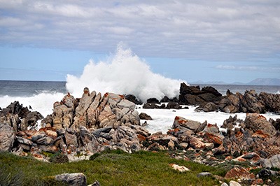
Rapid circulation is one of the factors that keeps False Bay’s water from stagnating. Photo Wikimedia Commons
Science for community
Fawcett sees the False Bay project as more than a scientific exercise. It has a strong community aspect.
“In the longer term, it’s also about the livelihoods of the fishers.”
As water quality likely affects fish prevalence, a future aim is to incorporate information on this into communication mechanisms, such as an app, for small-scale fishermen.
“If we notice the water quality is poor – for instance, if high concentrations of these nutrients or pollutants associate with certain wind and weather patterns − we could use this information, perhaps incorporate this into the Abalobi app*, to warn fishers. For example, Gordon’s Bay gets very stagnant at times. From the monitoring programme, we should be able to figure out if this is likely to mean poor water quality.
“It’s just another piece of information that may help fishers make smart decisions about when and where they fish.”
But science doesn’t have all the answers about histories of fish in the bay. Here it’s important to tap into generations of local fisher knowledge of fishing patterns and sea conditions.
“We can’t measure the bay’s nutrient concentrations of 50 years ago, but we can incorporate information based on what the local fishers know about changes in fish abundance. That might tell us something about how pollutants have driven fish out of certain areas.”
*The Abalobi app was designed by UCT’s Dr Serge Raemaekers of Environmental and Geographic Science.
