Objectives
The SBAPP Regional Project aims to build biodiversity knowledge for action in Southern Africa through Spatial Biodiversity Assessment, Prioritization, and Planning in South Africa, Namibia, Mozambique, and Malawi. Objective 4 of the project is to develop national spatial databases on ecological condition or land degradation for each of the four partner countries. Each country will produce their own national spatial databases but there will be a high degree of collaboration and interaction among the partners.
These databases will be used to inform how we monitor and report on:
- The IUCN Red List of Ecosystems;
- Targets for the Kunming – Montreal Global Biodiversity Framework.
- Achieving Land Degradation Neutrality targets of the UNCCD.
- Identifying areas for restoration.
Overall, ecological condition and land degradation data can be used to provide relevant information for decision-makers, planners, and researchers to make informed decisions regarding the sustainable use of ecosystems and conservation thereof to ensure they are not further degraded and remain intact.
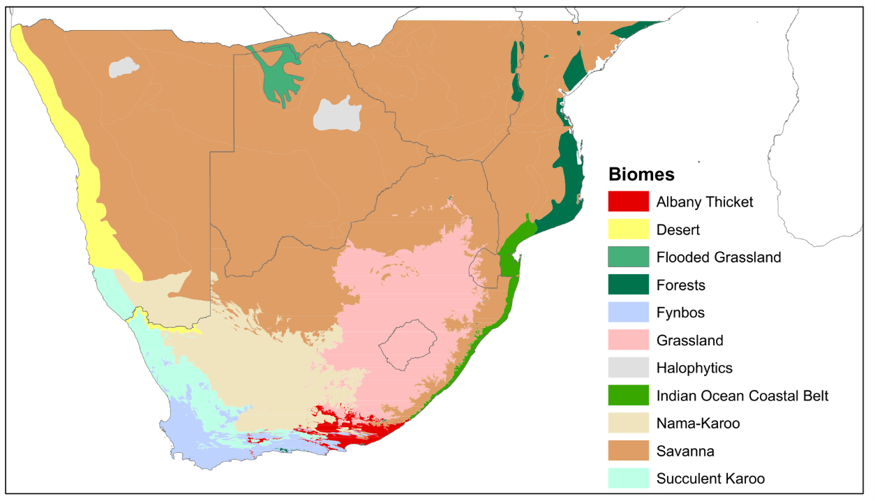
The SBAPP project distinguishes itself from other mapping initiatives related to ecological condition and land degradation in southern Africa, such as the Biodiversity Intactness Index (BII) for Africa. The BII is based on ecosystem extent, species richness and abundance measures to map the state of biodiversity. While the BII focuses solely on biodiversity as an indicator, the SBAPP project will focus on the states and processes at the biome level and will also consider various physical, chemical, and biological indicators related to ecological condition. These include the presence of invasive alien plants, fire regime disruptions, and the occurrence of soil erosion, for example, providing a more holistic view of ecosystem health and functionality, as well as the deterioration in land quality.
Timelines
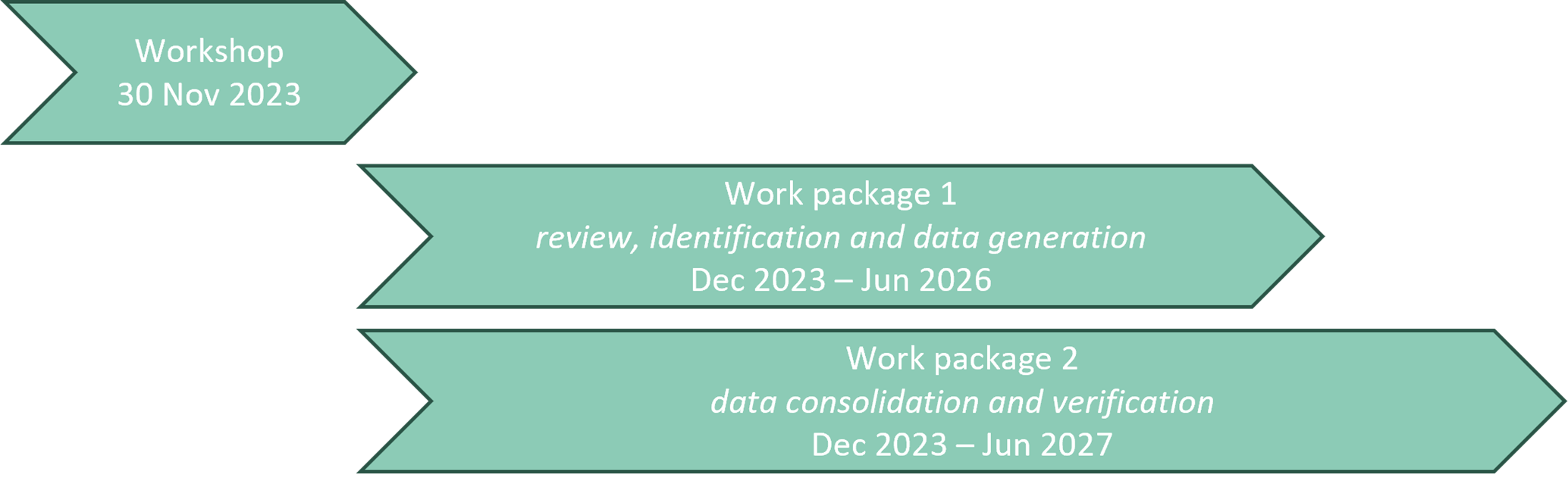
The SBAPP project was officially started in June 2023 and will run until June 2027. The main work of the ecological condition component of SBAPP commenced in earnest with a virtual workshop held on 30 November 2023 to which experts on ecological condition mapping and monitoring attended. The project will comprise two work packages running broadly in parallel with one another, as described below.
Background
Declining ecological condition, also known as land degradation, is a pressing concern in southern Africa due to factors like habitat transformation, climate change, deforestation, unsustainable farming practices, and invasive alien plants. Accurate mapping of ecological condition and land degradation is challenging, requiring diverse data sources like remote sensing data. Despite these challenges, mapping ecological condition is essential for understanding the extent of the issue and developing effective conservation strategies, necessitating collaboration among stakeholders and spatial data integration.
Globally, land degradation has gained significant policy attention, exemplified by the adoption of the Kunming-Montreal Global Biodiversity Framework by the UN Convention on Biological Diversity in December 2022. This framework includes Target #2, aiming to restore 30% of degraded ecosystems. However, achieving this target is hindered by the absence of mechanisms for collecting area-based information on ecosystem restoration and the lack of universally agreed-upon methods. The five-year SBAPP project, funded by the Agence Française de Développement (AFD) and the Fonds Français pour l’Environnement Mondial (FFEM) and led by SANBI, aims to enhance biodiversity assessments in four southern African countries, strengthening biodiversity knowledge to inform land use planning, decision-making, and environmental policy. Specifically, the project's "ecological condition" component focuses on identifying ecosystem change and threats, ultimately compiling spatial data for assessing ecosystems and species threat status.
Virtual Workshop - 30 Nov 2023
Based on the need to bring together various relevant stakeholders with interests in ecosystem condition and land degradation along with relevant spatial datasets, we held a virtual workshop to introduce interested parties to the ecosystem condition component of the SBAPP project in November 2023.
The workshop was attended by 86 people from ~17 different institutions across South Africa and nine institutions in other countries, including Malawi, Namibia, France, Germany and the USA. The workshop began with an introduction to the broader SBAPP project and, thereafter, talks on the rationale and proposed approach for the ecosystem condition component of the project. To provide a flavour of the type of work that is already ongoing in South Africa on mapping and monitoring ecosystem condition, we heard talks from five local experts (Dr Hayley Clements, Dr Jasper Slingsby, Prof. Onisimo Mutanga, Ms Nancy Job and Dr Glenn Moncrieff). The final part of the workshop was dedicated to:
- Identifying relevant available datasets and research (current and planned);
- Discussing the optimal approach for the planned work;
- An outline of the small grants programme planned under this component and suggestions for how best to use this money.
For more information on the workshop, please take a look at the Workshop Report.
Participants were asked to contribute to the links below. Readers are also still welcome to contribute to the following:
- A survey asking various questions from data/knowledge holders.
- A spreadsheet of references for a literature review (published data and grey literature, but also let us know of unpublished data or ongoing initiatives of note):
- A Felt map to post datasets that you know of in a specific location (please post details about the dataset – e.g. year – and give your name and institution)
You can download PDFs of the presentations given at the workshop here (numbers per agenda item in the Workshop Report):
- Carol Poole (2): Overview of the SBAPP Regional Project.
- Andrew Skowno (3): How condition data informs biodiversity assessment and planning.
- Vernon Visser (4): Overview of the SBAPP ecosystem condition component.
- Hayley Clements (5.1): Biodiversity Intactness Index for Africa (BII4Africa).
- Jasper Slingsby (5.2): Fynbos condition models and BioSCape programme.
- Onisimo Mutanga (5.3): Grassland productivity mapping in the context of ecosystem services and degradation.
- Nancy Job (5.4): Ecological condition from a catchment health perspective.
- Glenn Moncrieff (5.5): Global efforts to map ecological condition.
The ecological condition team also presented the planned approach for mapping ecological condition at the Thicket Forum 2024, Grassland Society of Southern Africa congress 2024, Fynbos Forum 2024 and Biological Invasions Symposium 2024 to get invaluable feedback from key stakeholders and expand the network of experts that will guide the interpretation of the condition in each biome. It is fundamental that stakeholders from each biome and experts in each aspect of ecological condition are involved from the outset of the project to ensure its long-term success.
View the presentation presented at the Thicket Forum 2024 for a description of the general approach planned to assess ecological condition for the Thicket biome as an example:
- Stephni van der Merwe: Help us map ecological condition in the Thicket biome.
This introductory workshop and conference engagement has been assisting the team to get a general idea of the current status of ecological condition and land degradation research and available datasets for these Southern African countries. This helped to identify and establish research priorities for aspects of ecological condition and land degradation that are still inadequately understood and mapped in Southern Africa, particularly from a remote sensing perspective.
Work packages
The project will be divided into two distinct work packages, 1) Review, ID, generate; and 2) Consolidate & verify.
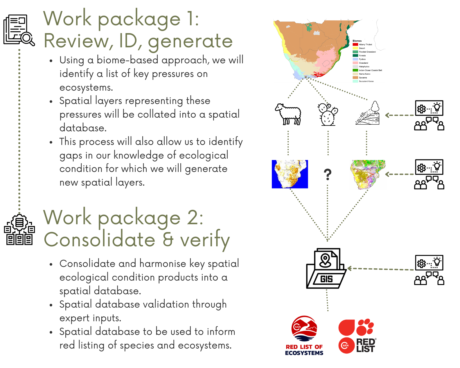
Work package 1 will focus on compiling existing spatial data and developing new spatial data on terrestrial ecological condition at both national and regional levels. This will be achieved using a biome-level approach through which degradation processes will be identified for each biome through a combination of expert elicitation and literature reviews (Figure below). Once a list of degradation processes has been identified for each biome, we will again use expert elicitation, a literature search together with an internet search to identify suitable spatial layers either representing or serving as proxies of these processes. This process will also enable us to identify gaps in the availability of suitable spatial layers. For these gaps, we have funding available for small grants which we will disburse to selected research groups to develop suitable spatial layers.
Work package 2 will consolidate and harmonise key spatial ecological condition products into a spatial database. The database will be used primarily for assessments of ecosystems and species threat status (Red Lists), and conservation planning; but will also be used to inform other national and international reporting requirements, such as the Land Degradation Neutrality aspects of the United Nations Convention to Combat Desertification (UNCCD). Outputs of the spatial database will be validated through inputs from the expert working group established during the first phase of the project.
Project team
- Stephni van der Merwe – Postdoctoral Research Fellow (UCT/SANBI) (please reach out: s.vandermerwe@sanbi.org.za)
- Sharndre Heuvel – Project Manager (SANBI)
- Carol Poole – Project Manager (SANBI)
- Andrew Skowno – SANBI Science Lead
- Vernon Visser – UCT Science Lead
- Timm Hoffman – Co-investigator (UCT)
- Graham von Maltitz – Co-investigator (SANBI)
- Colleen Seymour – Co-investigator (SANBI)
- Basetsane Malubane – SANBI Intern
- Curtley Tonkin – PhD Student focussing on Fynbos (UCT)
- Wataru Tokura – PhD Student focusing on the Nama Karoo (UCT)