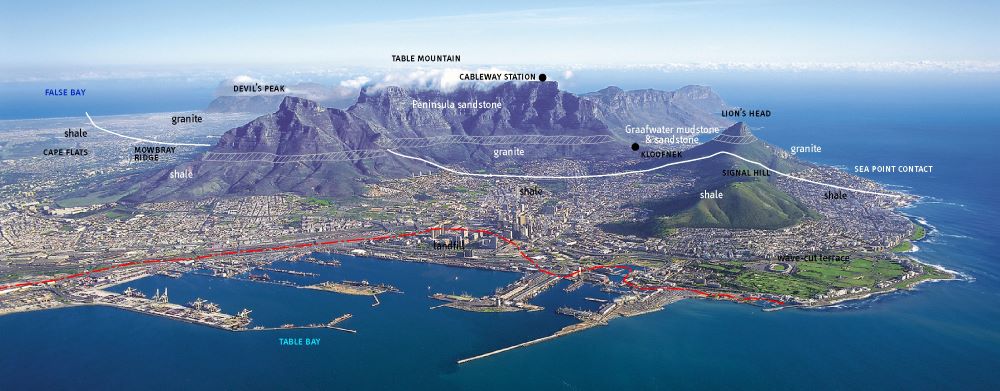
An appreciation of the magnificent sea and mountain views of Cape Town can be enriched by knowledge of its geological foundations. This page is provided as an introduction to the geology of the Cape Town area for schools and the general public. The rocks of the Cape are beautifully exposed and you do need not be a geologist to recognise the layers of hard sandstone forming the upper cliffs of Table Mountain, or to see that these layers were once continuously connected to those on Lion’s Head and Devil’s Peak, long since eroded away. Along the coast are fresh, wave-washed exposures of ancient sediment layers of the Malmesbury Group and large rounded outcrops of granite, an igneous rock with large, blocky crystals of feldspar. So, go out and explore and keep an eye out for explanatory plaques erected at sites of geological interest by the Western Branch of the Geological Society of South Africa Geoheritage committee.
A brief history of the rocks at the Cape
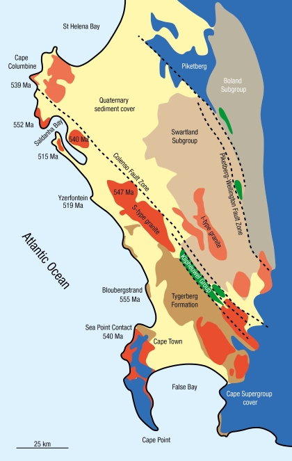
The Malmesbury Group rocks are the oldest in the area, consisting of alternating layers of dark grey fine-grained greywacke sandstone and shale. The freshest exposures are best seen along the rocky Sea Point and Bloubergstrand shorelines (see Figure 3). The Malmesbury rocks are difficult to date, but volcanic rocks within the Malmesbury shale at Bloubergstrand suggest it is at least 555±5 million years old. The Malmesbury sediments were originally deposited by submarine slumping and turbidity currents on the ancient continental margin of the Adamastor Ocean, the ocean basin that existed before the Atlantic Ocean.
The tectonic closure of the Adamastor Ocean resulted in the collision of the South American and African continents and the formation of the supercontinent Gondwana. The heat and pressure of the collision metamorphosed and folded the Malmesbury sediments, Tight folding with fold axes running in a NW direction is why Malmesbury rock layers are now almost vertical.
The Malmesbury Group was intruded by the Cape Granite Suite as the Adamastor oceanic crust was subducted beneath Africa. Large plumes of molten granite magma rose from great depths off the down-going slab before crystallising into huge, rounded batholiths from 550 to 515 million years ago. Most of the Cape Peninsula is one of these granite batholiths and was formed about 540 million years ago, Paarl Rock and the Darling Hills are other examples of granite batholiths.These batholiths were originally 5-10 km below the surface, cooling slowly and forming the large feldspar crystals. They have since been exposed by prolonged uplift and erosion along with the deeply buried Malmesbury shale they intruded.The rounded shapes of granite outcrops seen along the coast ,for example at Llandudno and Simons Town, reflect how granite weathers by exfoliation, like the unpeeling of the layers of an onion.
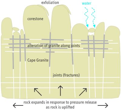
Close up, the granite is a coarse-grained rock consisting of large (2-8 cm) white blocky feldspar crystals, glassy quartz and black flakes of biotite, and inclusions (xenoliths) of ripped off pieces of Malmesbury shale, baked into a recrystallised dark rock called hornfels. In some places, intense weathering has altered the granite to kaolin clay that can cause slope stability problems in road cuttings. Kaolin was mined from the Sun Valley between Fish Hoek and Noordhoek that formed from deep weathering of the granite along a major fault.
The Sea Point Contact
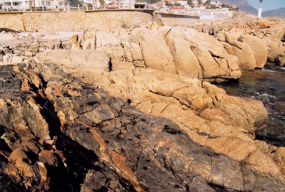
The contact zone where the Malmesbury Group was intruded by molten granite can be seen at the Sea Point Contact and was made famous by Charles Darwin when he visited it near the end of his voyage of scientific discovery on H.M.S. Beagle in 1836. Here, beds of dark coloured Malmesbury rock, altered by intense heat are intermingled and folded with the light-coloured intrusive granite. The contact was originally described from bedrock exposures of the Platteklip stream bed in Deer Park in 1812 by Captain Basil Hall.
Though initially intruded at great depth, prolonged uplift and erosion eventually exposed the granite and Malmesbury shale at the surface, forming an extensive peneplain on which the thick pile of sedimentary rocks of the Cape Supergroup were deposited as the basement rock subsided between roughly 500 to 340 million years ago.
Sediment from the northern highlands was eroded and transported by braided river channels to the margins of the Agulhas Sea (Cape Basin). The lowermost Table Mountain Group (TMG) is what we see in the Cape Town area, but the entire sediment pile can be seen by crossing the Cape Fold Belt mountains. The sediment is thought to have been deposited in a mix of riverine and coastal deposits, extensively reworked as sea level rose and fell repeatedly. The TMG was deposited from about 500 to 440 million years ago and its lowermost Graafwater, Peninsula and Pakhuis formations make up Table Mountain. The spectacular Chapmans Peak Drive was constructed along the contact unconformity between granite and the overlying Table Mountain Group sequence.
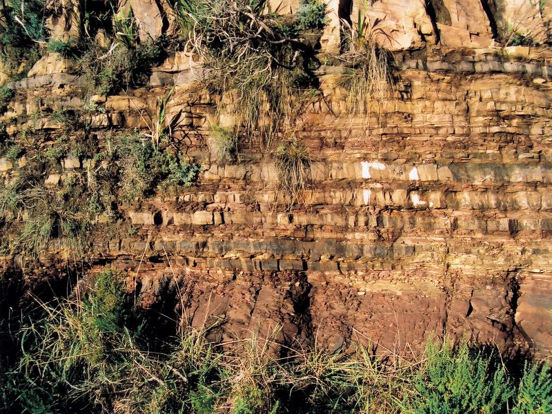
The basal Graafwater Formation (80-100 m thick) consists of distinctively maroon coloured interlayered mudstone and sandstone that are best seen in road cuttings on the slopes of Table Mountain and along Chapmans Peak Drive. Closer examination shows deposition cycles from current-bedded channel sandstones to increasing proportions of fine-grained maroon mudstone at the top, deposited in flood plains and lagoons. It contains rare tracks (trace fossils) of the horseshoe crab-like animals living at the time.
The overlying Peninsula Formation (800-1500 m thick) consists of hard, light grey quartz arenite sandstone. The sandstone is composed of 95% or more quartz sand grains and cement and is extremely resistant to erosion, forming the oversteepen mountain cliff faces. Current bedding and white quartz pebble layers suggest that it was originally deposited as migrating sand bars in broad river channels or on high-energy beaches.
The Pakhuis Formation is a lithified glacial outwash deposit and occurs on the highest points of Table Mountain, such as Maclears Beacon. It contains rounded to angular pebbles that were deposited at a time when the Cape was situated close to the South Pole.
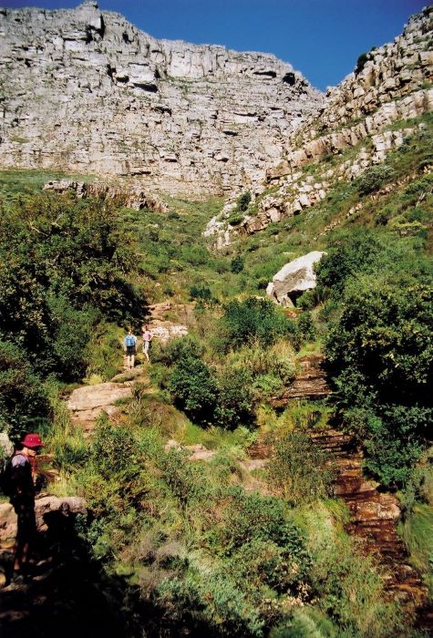
The sand, silt and mud deposits of the Table Mountain Group were lithified by deep burial and then deformed during tectonic closure of the Agulhas Sea. The intense deformation of the collision is spectacularly on display in the Cape Fold Belt, a mountain chain that extends 800 km along the southern coast to Port Elizabeth and 300 km to the north as the Cederberg Mountains and is part of a much larger mountain chain that extends into South America and Antarctica in the final assembly of Gondwana.
Gondwana started to break apart 180 to 135 million years ago. Faults, mostly extensional faults that formed at the time of the breakup of Gondawana, cut across and displace the rock layers of Table Mountain. These more easily eroded fault zones are marked by ravines, for instance, cross-cutting faults separate multiple peaks (buttresses) of the Twelve Apostles seen above Camps Bay. Dark dolerite dykes intruded into the Cape heralding the breakup of South America and Africa, forming the Atlantic Ocean basin. These dark, igneous dykes can be seen at Froggy Pond near Simons Town, cutting through the granite. The dolerite dykes are not to be confused by later manganese deposits that formed along fault zones, some of which were briefly mined at Hout Bay.
Why is Table Mountain flat?
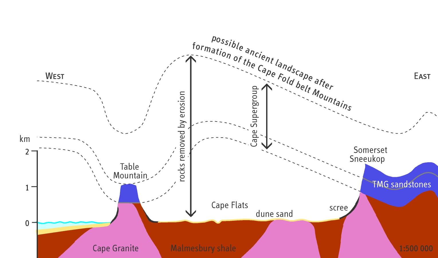
Table Mountain may represent the trough of a large fold that was downfaulted to a lower position than surrounding areas. As a result, it is the last bit of resistant sandstone rock to be exposed at the surface, the surrounding rocks having been eroded away. Table Mountain and the Cape Peninsula represent an erosional outlier to the Cape Fold Belt, as do Riebeeck Kasteel and Piketberg to the north.
Recent Events
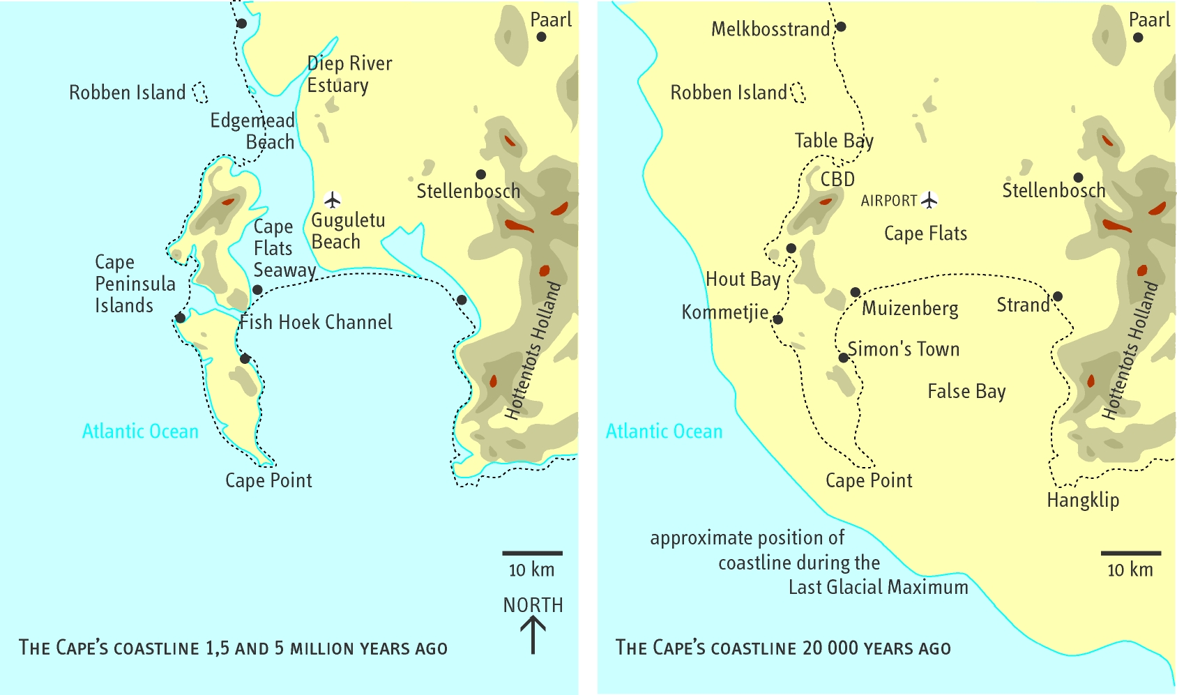
Much of the low-lying areas of the Cape Peninsula and Cape Flats are blanketed by a thin veneer of eolian (windblown) and marine sands. Sea level has fluctuated between 120 below to 25 m above present-day over the last 5 million years. Sea level has fluctuated over the last one million years as a result of fluctuating global temperature and variable amounts of water accumulated in polar ice caps. At times of maximum ice build-up, False Bay and Robben Island were completely exposed as dry land, while at times of minimal ice the sea covered the Cape Flats and Sun Valley and the Cape Peninsula was then a group of islands. Weathering of calcareous beach sands forms subsurface layers of calcite-cemented limestone called calcrete, exposed along the West Coast, that forms by leaching of the shell fragments and precipitation of calcite in the soil during the warm dry summer months. Active dune fields once existed across much of the Cape Flats before they were planted with alien vegetation, while the Atlantis and Yzerfontein-Geelbek dune fields to the north are still active.